Friday 20 September 2013

Icom IC-M23 VHF Marine Radio

Safety is paramount and the most important priority to consider when going out to sea kayak fishing.  Although I study several weather and shipping forecasts prior to any trip I can never really be 100% sure what may happen when I am out there.  The Cornish coast is like any coast, it can change very quickly and unexpectedly.

Since taking up kayak fishing, I have acquired several safety items for that 'just in case situation'.  For example, suitable clothing, a spare paddle, a paddle float to assist re-entry, a throw line attached to my waist to ensure contact with the kayak in the event of a capsize, a first aid box, a whistle, a knife to cut myself free in the event of entanglement, a bilge pump, a compass, and a GPS navigation device.

To date, most of my kayak fishing trips has been solo.  One vital piece of safety equipment was missing from my list, suitable communication!  A mobile phone in a dry bag seems a good idea except if there are signal problems or the phone gets wet in a capsize situation rendering it useless.

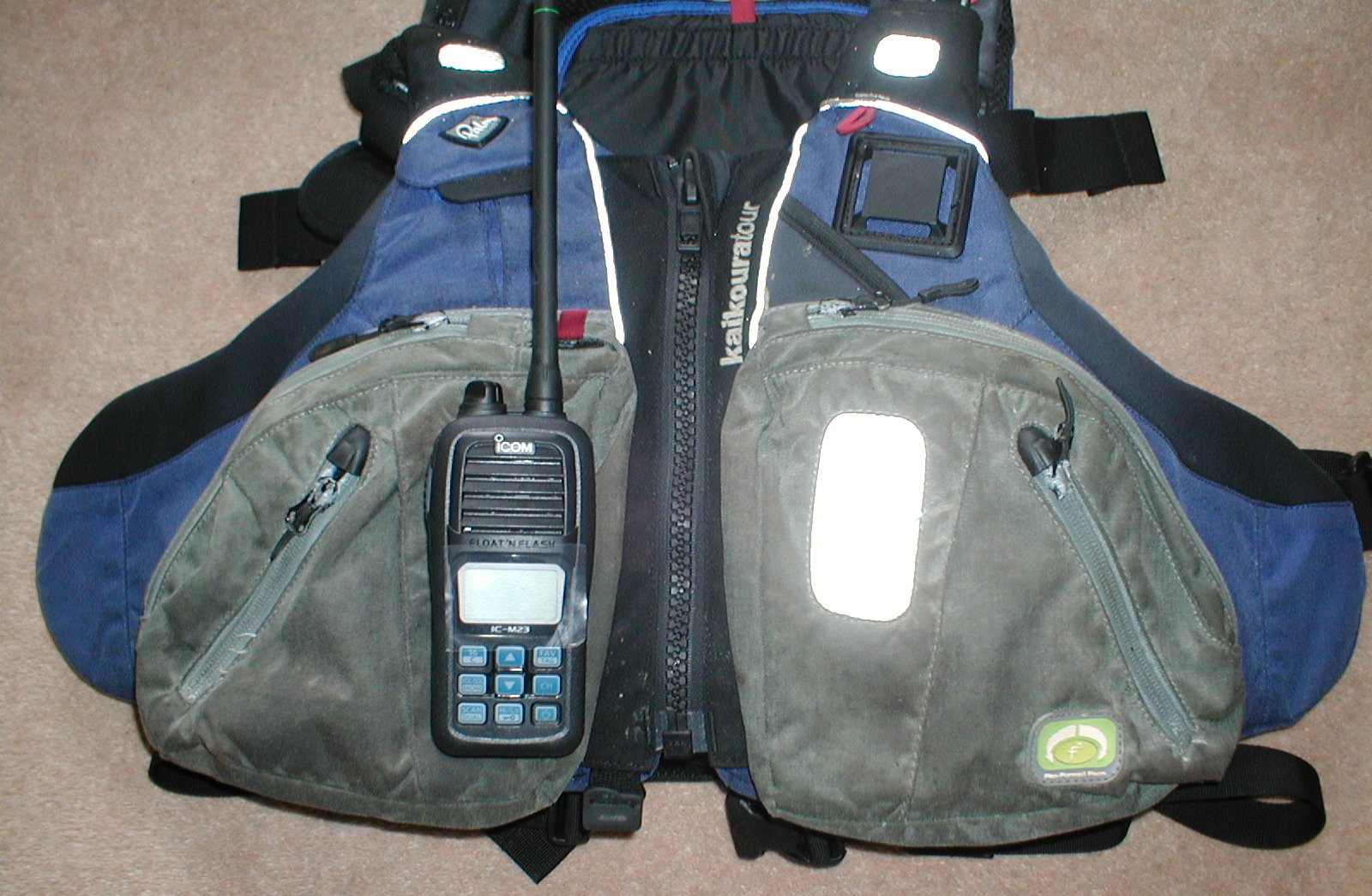
To solve that 'just in case' communication problem I have now purchased an Icom IC-M23 Bouyant VHF Marine Handheld Radio.


In the event of a capsize, the radio is waterproof when fully submerged for up to 30 minutes and is designed to float and flash when in water.  It is small measuring only 13cm in height and small enough to fit in the right pocket of my Palm Kaikoura Tour PFD.  The pocket is designed for a VHF radio therefore, an ideal place to store it.


In case of an emergency requiring assistance, I could contact the coast guard and other vessels by sending a distress call on channel 16.  In addition, a recently purchased handheld GPS would enable me to give my current coordinates thus assisting any rescue team in finding me.

However, before being able to use the radio legally I have to obtain an operator's license by attending a one-day marine radio and GMDSS course at my local Truro College at a cost of £80 plus £30 for the certificate.  I have booked myself on the next available course in a couple of week's time. 

The Global Maritime Distress and Safety System (GMDSS) is an international system, which uses terrestrial and satellite technology and shipboard radio-systems to ensure rapid and automated alerting of shore based communication and rescue authorities.  The communication also goes out to ships in the immediate vicinity in the event of a marine distress.

Although I will not be taking any more chances with the sea the addition of the VHF radio has definitely given me more confidence that should I find myself in a distress situation I now have suitable back up to call upon.


Monday 16 September 2013

Fitting a Navigation Device - Garmin GPSMap 78

Fitting a fish finder earlier in the year has greatly enhanced my fishing capabilities and experience. The facility to be able to see the structure of the seabed, the depth of the water and find shoals of fish has been fascinating and educational. To enhance that experience even more it would be great to be able to mark the waypoints of features I fish over such as rough ground marks, wrecks, pools, gullies, banks etc. This would enable me to navigate back to those marks with far greater accuracy rather than having to use landmarks, a compass, and the fish finder.

Apart from navigating to fishing marks there is the safety element a GPS navigation device would bring.  Being able to mark launch sites would give some peace of mind should the fog roll in making visibility impossible.  A GPS would help me navigate back to the launch site in such poor visibility.  In addition, should I need to give out a distress call I could give coordinates of my current position thus helping any rescue team locate me.

I have been very pleased with the performance of the Garmin Echo 550c fish finder therefore, decided to stick with Garmin and purchase the GPSMap 78.


The device has all the features and specifications I needed.  It comes with a world base map however; there is an option to purchase detailed marine charts called Garmin BlueChart g2 installed via a micro SD card. The blue charts have a fishing chart, which displays detailed bathymetric contour lines; this would be very useful in selecting marks to fish.


In addition, with the purchase of the marine planning software HomePort, waypoints and routes can be planned at home on the computer and transferred to the device. This option particularly appealed to me.


Although the unit is a handheld unit that could be kept in a pocket, I wanted to fit a GPS mount on the kayak that would enable me to view the map and route whilst paddling.  To do this I purchased the following components:

1 x Ram Holder for GPSMap 78 (Ram-Hol-GA40)
1 x Diamond Base with 1" Ball (Ram-B-238)
1 x Double Arm Socket for 1" Ball (Ram-B-201)
1 x YakAttack ScrewBall 1"


I mounted my fish finder on a 16" GearTrac.


It was always my plan to use the GearTrac to fit other devices and this is ideal for mounting the GPSMap 78.

First job was to fit the 1" diamond base to the back of the GPS holder using the screws and lock nuts provided.


Next, I needed to secure one end of the 1" double arm socket to the diamond base.


The YakAttack screwball screws on to the GearTrac.


To complete the mount I fixed the other end of the double arm socket to the YakAttack screwball.


The device sits nicely now alongside the fish finder and within reach from my seat and can be tilted forward if necessary.


I mentioned the option to purchase BlueChart g2 marine charts.  Direct from Garmin, I purchased the chart for my location in the southwest called HEU463S - Bristol Channel & England S/W.


The chart is pre installed on a micro SD card that simply slots in underneath the batteries.


I also purchased the marine planning software HomePort, and downloaded the software direct to the computer from Garmin.  HomePort enables me to view the marine BlueChart g2 on the computer by plugging the GPSMap 78 into the computer via the USB cable provided.

There is a choice to view the charts in either navigation mode, fishing chart mode, or both.


Setting waypoints and sending that waypoint to the GPS is straightforward. 

First impressions of the Garmin GPSMap 78, the Blue Chart g2, and the HomePort software are impressive and I shall look forward to using these facilities to enhance my fishing experience even more.


Thursday 5 September 2013

Kayak Sea Bass Fishing and a Mixed Catch

I usually focus on catching Sea Bass from September through to the end of December.  Bass are around earlier but in the autumn, they tend to be more abundant.

I had a couple of free days this week and with a favourable weather forecast what better way of spending that time than out on the kayak fishing.  When I have the time to fish the whole six hours of a flooding tide I sometimes like to vary the methods used and therefore, vary the species caught.

Concerning Sea Bass fishing, experience has taught me that there are times of activity and times when you might as well pack up and go home.  In 25 years Bass fishing I have never caught Bass for the whole six hours of a flooding or ebbing tide.  Therefore, rather than waste the non-productive time in the hope of a catch, I would rather target Bass during the time of the tide when I am most likely to catch and then go for other species.

My chosen mark produces Bass in the first three hours of the flooding tide.  My plan was to spend those first three hours drifting and trolling using lures after which I would paddle out to deeper water and fish at anchor.  At anchor, one rod would be used to fish with bait on the bottom targeting Thornback Ray or Bull Huss and whilst waiting for a bite, I would jig a Herring Rig targeting Mackerel or Herring.

When lure fishing for Bass from the kayak I like to combine drifting with trolling.  The idea is to set up the drift over the chosen mark and deploy the drift chute at the stern, which turns the stern of the kayak into the wind.  With the stern into the wind, I am facing down wind, which makes it easier to cast the lures down wind and to the sides covering as much ground as possible.  This also of course slows down the drift giving much more fishing time.


When paddling back up tide/wind to reset the drift, rather than just paddling back it often pays to troll a lure at the same time.  This way in effect you are always fishing.


On day one of my two-day trip, I launched an hour earlier than low water to pick up some fresh bait for the bait fishing at anchor later in the day.  One the bait had been secured I could then focus on the Bass fishing.

The mark is shallow rough ground and I would be drifting over depths ranging from 3' to 15'.  I mentioned in a previous post Top Sea Bass Lures the lures I like to use when Bass fishing.  For this trip, I carried the following plugs, a Tackle House Feed Shallow 128, a Savage Prey 130, and a Megabass Zonk 120 Gataride - Hi Pitch.  These floating diving plugs give me a diving range from 1' to 4'.  Generally, even in the deeper water the Bass will rise up from underneath to take the lure. 


The three hours Bass fishing produced two fish.  One caught trolling and one drifting and both took the Tackle House Feed Shallow.

The three hours spent fishing at anchor produced nothing from the bait rod however, the jigged Herring Rig produced a Gurnard, Mackerel, and to my delight a Squid.


The mixed methods of day one produced a mixed catch which was pleasing.


On day two, I planned to repeat the tactics of day one.  First, I needed some fresh bait for later and fortunately, Mackerel showed on the fish finder.   Interestingly, you can see the lure going down to the shoal and jigging amongst them.  A fish finder can be very useful at times and since fitting the Garmin Echo 550c I have been very pleased with its performance, the returns are excellent and very clear.


Once again, with the bait secured for later it was time to focus on the Bass fishing with lures.  This time the session produced three Bass all caught trolling the Tackle House Feed Shallow.  Two of the Bass were undersize and returned.


With the Bass fishing session over the fishing at anchor in deeper water began.  This time the session produced fish on both the bait rod and the jigged Herring Rig.  The bait rod produced a nice Bull Huss on fresh Mackerel, and the jigged lure produced a few more Mackerel and a Horse Mackerel.  Interesting how dark the back is on the Bull Huss.


It is always pleasing when a plan works out and for me the most interesting catch over the two days was the squid simply because I do not usually catch them.  I have read that squid fishing is becoming more popular in the UK.  I may invest in some squid jigs and add squid as a target species to catch for the dinner table.