I recently purchased a Garmin GPSMap 78 handheld
navigation device along with the Garmin Marine BlueCharts g2, and the
Garmin HomePort marine planning software. The ability to be able to
use my computer and the HomePort software to create waypoints to various
fishing marks and to be able to navigate to those marks with ease using the GPS
has greatly enhanced my fishing experience. In addition, the ability
to be able to create tracks over ground I want to troll means, I can now
cover that ground with far greater accuracy than before.


Creating waypoints using the HomePort
software and the marine BlueCharts g2 and then sending
those waypoints to the GPS is easy. The marine chart is stored on the
GPSMap 78 via a micro SD card. By opening the HomePort software and plugging the
GPSMap 78 into the computer via the USB lead provided, the marine chart
displays on the screen.

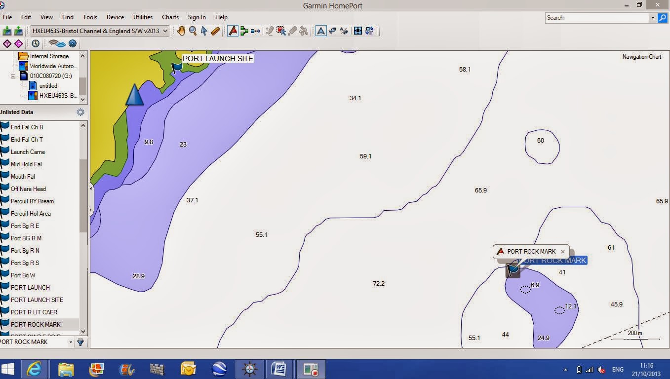
To create waypoints I select the waypoint tool
and click on the marks I want. In this
example, it is the launch site and the fishing mark.


I then name the newly created waypoints in
a name of my choice by right clicking on the waypoints located in the left
column and selecting rename.
Sending those waypoints to the GPSMap 78 is a
matter of right clicking on the waypoint located on the left column, selecting
Send To, and then selecting the Garmin GPSMap 78.


By selecting Go To via the waypoint manager on
the GPSMap 78 a track is created assisting the navigation to that mark.

One enjoyable method of kayak fishing
for Bass and other species is trolling.
Although physically hard work, it is relaxing, good exercise, and from a
fishing point of view can be rewarding. Cornish commercial line fishermen
use this method for Bass, Pollack, and Mackerel and they call it whiffing which
just means trolling a lure slowly from boat at just enough speed to get
the lure working.
In the past, I have trolled areas using landmarks
to determine my location and the fish finder to determine the depth
however, apart from when hugging the shoreline, I could never be sure
exactly where I was, or the ground I had previously trolled.
With the HomePort software and the BlueCharts, I
can now set tracks over the ground I want to troll and send those tracks to the
GPSMap 78. When trolling, I can follow those tracks enabling me
to cover nearly all of the ground. In addition, if I catch in a
certain area I will know exactly which track I was trolling and can repeat the
troll along the same track as it may be an indication a fish holding
area.

To create tracks I select the ‘New Track’
tool and simply click and drag the tool over the area I want and repeat
the process until I have created all of the tracks required.


As with the waypoints, I rename the tracks with
a name of my choice and send them to the GPSMap 78. To activate the tracks I simply select
'Show on Map' via the track manager.
Although the marine BlueCharts are excellent they do not show areas of underwater rough ground unless that rough ground exposes at some point in the tide therefore, unfortunately, I cannot use the marine chart to create waypoints to those marks. However, some of those marks show on Google Satellite Maps or Google Earth and I can use Google to create waypoints and then transfer those waypoints to the BlueChart. The following is an example of small rough ground marks, which act as an oasis to fish such as Pollack.

Although the marine BlueCharts are excellent they do not show areas of underwater rough ground unless that rough ground exposes at some point in the tide therefore, unfortunately, I cannot use the marine chart to create waypoints to those marks. However, some of those marks show on Google Satellite Maps or Google Earth and I can use Google to create waypoints and then transfer those waypoints to the BlueChart. The following is an example of small rough ground marks, which act as an oasis to fish such as Pollack.

The same area on the BlueCharts unfortunately, does not show the submerged features.

To create a waypoint using Google Earth I first create a place mark by selecting the 'Add Placemark' tool then reposition the place mark on the mark.

This gives me the coordinates I need to create the waypoint on the BlueChart.

Back on HomePort with the BlueChart open, I then create a new waypoint in roughly the area of the mark then copy and paste the correct coordinates from Google Earth. This creates the new waypoint in the correct position ready to name and send to the GPS.

The only negative I can find with the Garmin BlueChart is that apart from exposed rocks and submerged wrecks it does not show submerged rock marks. This area, which has several small-submerged rocky areas, shows only as a sandy bottom on the chart. However, this may be typical of electronic marine charts.
These facilities may or may not improve my catch however, one thing is for sure, it has certainly enhanced my fishing experience making it more interesting and satisfying.